01 December 2010

Kingdoms of the Kithain

Ok, I know I'm three months overdue for an update (for which I apologise). The last update was supposed to be a map of the continent, but I'm having trouble getting that finished. Maybe I'll accomplish that task one day, but for now, I think it's best to move on to other topics.

So I would like some input on an issue that has bugged me in the past. I was looking through the old image files I created to develop a complete set of maps for the kingdoms in Changeling: the Dreaming. And I remembered a point of contention; the four kingdoms of the Iberian Peninsula.

Here's the only thing that it says in any canonical release from White Wolf Studios:

Spain and Portugal -- Sometimes the allies of Neustria, four kingdoms comprise these lands of the Iberian Peninsula: Navarre along the Pyrennees, Aragon in the east, Leone in the Northeast, and Castille in the central and southern regions. Commoners, whether in service to a noble or not, are always welcomed; eshu and boggans are an integral part of the society.

This leaves me somewhat confused. For starters, where does Portugal fit into this? It's the western and southwestern part of the peninsula, neither of which are regions mentioned in the description. Also, it's not quite accurate to describe Castille as the 'central and southern regions,' either historically or in modern terms.

For more information, I refer you to a series of maps. First, we see a map of modern Spain, in which most of the administrative divisions are named after one kingdom or another in Spain's history:

A map of Spain showing the different administrative divisions. Spain is roughly quadrilateral, taller than it is wide, with the east coast sloping out so that the northern edge is wider than the southern edge, with a protrusion to the west in the northwest corner. The northwest protrusion is Galicia. Most of the northwest portion is taken up by Castilla y León, but the northern coast above Castilla y León is taken up by (from west to east) Principio de Asturias, Cantabria, País Vasco, and Navarra, with La Rioja sandwiched between Navarra and Castilla y León. To the east from these divisions is Aragón, and Cataluña takes up the northeast corner. Bordering these two provinces to the south is Comunidad Valenciana. South of that is Región de Murcia. The largest section takes up all of the southern coast: Andalucia. On the eastern edge, between Andalucia and Castilla y León, is Extremadura. The region in the centre of all of this is Castilla - La Mancha, except for a section of this area that border Castilla y León, which is the Comunidad de Madrid. There are a few islands noted on the map as well, such as the Islas Canaria and the Islas Baleares.

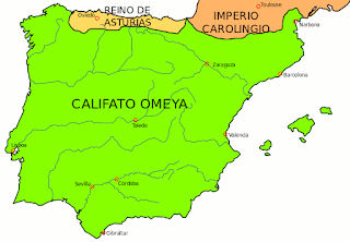
Then we go way back in history to the year 750 CE, when the Muslims had conquered almost the entirety of the peninsula, leaving just a couple of tiny christian kingdoms remaining in the north:

A map of the Iberian peninsula in 750 CE. Almost the entire peninsula is labelled as Califato Omeya, except a thin strip along the northern coast, which is the Reino de Asturias, and from just south of the Pyrenees Mountains up into France is labelled Imperio Carolingio.

If we jump ahead to the year 1000, we find this:

A map of the Iberian Peninsula, this time with roughly the bottom two thirds labelled as the Califato de Córdoba, a large chunk in the northwest labelled as León, a smaller section in the north central region labelled as Navarra, and the northeast from what is today Barcelona northward labelled as Francia.
Then we move to the year 1210:
A map of the Iberian peninsula in 1210 CE. The bottom half is largely taken up by Muslim territory, which extends across the Strait of Gibraltar into Africa. The northern half of what is now Portugal has become the earliest beginnings of that nation. Around it on the north and east is León. The east of León is Castille. East of Castille is Aragón, with the smaller kingdom of Navarre squished between them in their northern halves. To the east of Aragón is an area containing Barcelona and portions of southern France which is somewhat confusingly labelled on this map.

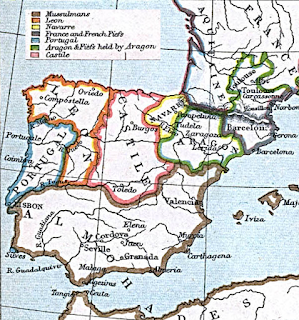
And the end of the Reconquista: This is what it looked like in 1300 CE. It stayed this way with the exception of several Spanish kingdoms merging together until the last Muslim kingdom was reconquered by the Catholic Kings in 1492:

This map is similar to the previous one, with the majority of kingdoms extending further south. The Muslim kingdom of Granada has been reduced to a small portion of the southeast coast. Portugal has taken its present-day form. The combined kingdoms of Galicia, Asturias, and Leon occupy the area around Portugal to the north and east, except a small portion of the southeast border of Portugal, which adjoins Castille. Castille takes up the central column of the peninsula, as well as all the area surrounding Granada, forming a sort of inverted T shape. Navarre has changed little, still occupying a small area in the northern central region. Aragon is a triangular kingdom extending from Navarre and France to a point in the south. Cataluña occupies nearly all of the east coast, from France down to the eastern portion of Castille, which has a small section of the southeastern coast.

So, what I want to know is this: Where do you think it makes most sense for the modern Kithain nations of Castille, Navarre, Aragon, and Leone to be? Please let me know what you think in the comments. And until next week, I bid you a fond 

Game on!

No comments:

Post a Comment

I'll be along soon to make sure your comment isn't spam. Until then, just sit tight! Unless your comment IS spam, in which case, bugger off.